Windy Venus and Rotation

Venus, Mars and Earth, three out of the four inner or ‘rocky’ planets of the Solar System, have a lot in common yet very different.
Their masses are basically the same, and their densities too. Their radii seem just copied from one planet to the other. Their distances from the Sun are not so different – Venus is about 108 million kilometres and Earth is 150 million kilometres.
Their rocks are both largely basaltic, result of intense volcanism and of a similar solidification process, initiated about at the same time, four and a half thousand million years ago, when the planets of the Solar System started to form from the solar ‘proto-planetary nebula’
RotationVenus rotates backwards with respect to Earth, so the Sun appears rising from west. It also rotates very slowly – one rotation, or sidereal day, takes 243 Earth days. This is longer than the Venusian year, 225 Earth days long. However its winds are so fast that they can circumnavigate the planet in only four Earth days.
Venus' dense atmosphere of carbon dioxide with surface pressures 90 times that of Earth (equivalent to what we find at 1000 metres below the surface of our oceans), causes a runaway greenhouse effect that raises the surface temperatures up to 450ºC, to such as extent that metals like lead are in a liquid state on Venus. At a height of between 45 km and 70 km above the surface there are dense layers of sulphuric acid clouds totally covering the planet.
In the 1960s it was discovered that the top level of cloud layers moved very rapidly, orbiting the planet in only four days, compared to the planet’s own orbit of 224 days. This phenomenon was baptised the
“superotation” of Venus: the winds carrying these clouds travel at 360 km/h.
Hurricane winds and huge atmospheric vortexes are being studied closely based on new data from Venus Express.
 Scientists from University of the Basque Country have discovered novel aspects of Venusian rotation.
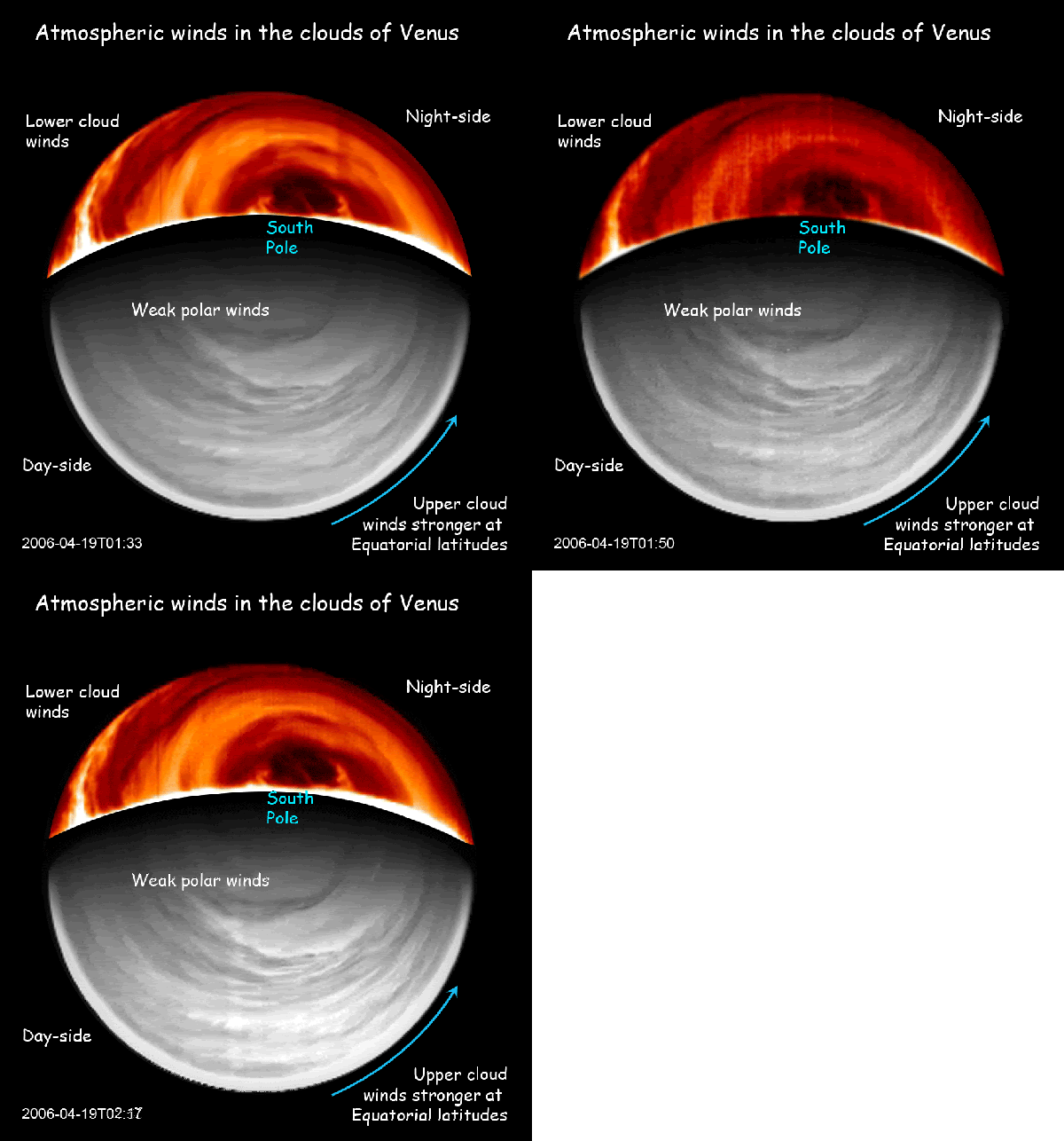
By using images recorded by both day and night on Venus with the VIRTIS spectral camera on board the Venus Express, scientists have succeeded in measuring these clouds over several months and have discovered new aspects of
the “superotation”. Firstly, between the equator and the median latitudes of the planet there dominates a superotation with constant winds blowing from East to West, within the clouds decreasing speed with height from 370 km/h to 180 km/h. At these median latitudes, the winds decrease to a standstill at the pole, where an immense vortex forms. Other aspects of the superrotation that observations with VIRTIS have made possible are that the meridional (North – South) movements are very weak, about 15 km/h, and, secondly, unlike what was previously believed, the superotation appears to be not so constant over time: “We have detected fluctuations in its speed that we do not yet understand”, stated the scientists. Moreover, for the first time they observed “the solar thermal tide” effect at high latitudes on Venus. “The relative movement of the Sun on the clouds and the intense heat deposited on them makes the superotation more intense at sunset than at sunrise”, they stated.
“Despite all the data brought together, we are still not able to explain why a planet than spins so slowly has hurricane global winds that are much more intense than terrestrial ones and are, moreover, concentrated at the top of its clouds” stated Mr Sánchez Lavega. This study has enabled advances to be made in a precise explanation of the origin of superotation in Venusian winds as well as in the knowledge of the general circulation of planetary atmospheres.

Credits: ESA (Image by AOES Medialab)Venus Express is studying largely unknown phenomena in the Venusian atmosphere like never before. Its suite of instruments is also digging into the interaction between the solar wind and the planetary environment. In addition, the mission is gathering glimpses of the planet's surface, which is strictly coupled with its dense atmosphere.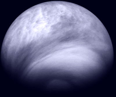
Credits: ESA/MPS/DLR/IDA
This beautiful, false-colour ultraviolet image of the Southern hemisphere of Venus was obtained by the Venus Monitoring Camera (VMC) on board ESA’s Venus Express on 27 July 2007. It was taken from a distance of 30 000 km from the planet’s surface at a wavelength of 365 nanometres. The planet is seen from the southern hemisphere: the south pole is at the bottom, while equator is at the top.
The shape of the clouds changes dramatically from the equator to the pole. At low latitudes, the cloud shape is spotty and fragmented, a consequence of a vigorous convective movement powered by the radiation of the sun heating the atmosphere itself. The bright lace visible on top of the darker cloud deck is made of freshly formed droplets of sulphuric acid.
At mid latitudes, the convective clouds make way for more streaky shapes indicating that the flow is basically laminar in this portion of the atmosphere.
At high latitudes, the cloud structure appears as a dense, almost featureless haze forming some a ‘polar cap’ on Venus. The dark, circular feature visible at the rightmost edge of the image is one of the dark streaks usually present in the polar region, indicating atmospheric parcels spiralling towards the pole.
Sources: Measuring Wind on Venus and ESA's Venus Express








 Posts
Posts


